Zoom Commands
Zoom In
The Zoom In command shows the area of the map at the center of the screen at a higher level of detail. The map scale is changed by a factor of two.
To zoom in on the map, do the following:
- View a Map.
- Then, do one of the following:
- On the , point to , and click .
- If your mouse has a scroll wheel, scroll away from you one step.
- Press +.
Zoom Out Command
The Zoom Out command shows the twice as much area as is currently being displayed, but at a lower level of detail. The map scale is changed by a factor of two.
To zoom out on the map, do the following:
- View a Map.
-
Then, do one of the following:
- On the , point to , and click .
- If your mouse has a scroll wheel, scroll toward you one step.
- Press -.
Zoom to Show All Data Command
The Zoom to Show All Data command zooms and recenters the map so that all data in the file is visible.
To view all of the data on the map, do the following:
- View a Map.
-
Then, do one of the following:
- On the , point to , and click .
- Press *.
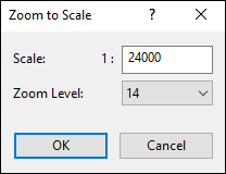
Zoom to Scale Command
The Zoom to Scale command allows you to change the scale of the map to match a printed map.
To change the map scale, do the following:
- View a Map.
-
Then, do one of the following:
- On the , point to , and click .
- Press : Colon.
The Zoom to Scale dialog will appear. Enter the new scale of the map.
Notes
- Topo Maps and Aerial Photos can only be viewed at fixed scales, which correspond to the number of meters per pixel in the map image.
- To print a topo map or aerial photo at a standard map scale (1:24000, e.g.), see the Print Map command.
Zoom to Original Size Command
The Zoom to Original Size command resets the scale of the map to the default scale for that map type.
| Map Type | Default Scale |
| White Background Map | Zoom to Show All Data |
| Topo Map | 4 meter/pixel scale |
| Aerial Photo Map | 4 meter/pixel scale |
| Scanned Map | Show Scanned Map at original size |
To reset the scale of the map, do the following:
- View a Map.
-
Then, do one of the following:
- On the , point to , and click .
- Press \.
© 1998-2026 TopoGrafix – 24 Kirkland Dr, Stow, MA – Email: support@expertgps.com