Terry F. asks:
![]() We are rural real estate appraisers in Montana. We use Magellan Explorist XLs and have one Magellan Mobile Mapper 6. We want to have the handheld screen to be a topo map that shows Section, Township and Ranges not the usual Long/Lat . Do you have or is there software available that will do that? Thanks.
We are rural real estate appraisers in Montana. We use Magellan Explorist XLs and have one Magellan Mobile Mapper 6. We want to have the handheld screen to be a topo map that shows Section, Township and Ranges not the usual Long/Lat . Do you have or is there software available that will do that? Thanks.![]()
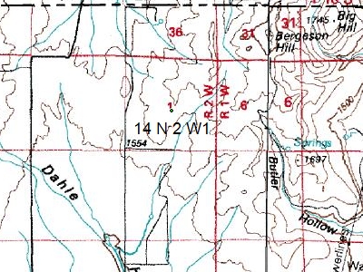
I don’t know of any handheld GPS receiver which can display Section, Township, and Range coordinates instead of latitude and longitude or UTM. However, ExpertGPS Pro now has the ability to display Public Land Survey System (PLSS) coordinates in Township, Section, and Range format. When run on a laptop in your vehicle and attached to a low-cost GPS receiver or GPS “mouse” antenna, ExpertGPS can function as a moving-map display, essentially turning your laptop into a full GPS receiver with a huge screen and full keyboard.
To use ExpertGPS as a moving map display, you’d use the Tracking feature, which polls your GPS receiver or antenna once every second and updates your location on the maps displayed on your laptop’s screen.
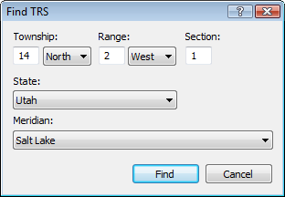
To go to a specific property, click Go to TRS on the Go menu, and enter the Section, Township, and Range into the Find TRS dialog. ExpertGPS will recenter the map on the property, and create a waypoint marking that location.
If you are in Tracking mode, you can navigate to the parcel by right-clicking the new waypoint and clicking Set Active Point. On the Tracking menu, click Navigate to Active Point.
You can get the TRS coordinates of any point on the map by looking in the lower-right corner of the main ExpertGPS Pro window. In addition to the latitude and longitude, UTM, or state plane coordinates of the cursor position, you’ll see the TRS coordinates as well.