Convert any coordinate format or datum with ExpertGPS
ExpertGPS isn't just a mapping tool and a GPS data manager, it's a powerful coordinate converter that can instantly convert between any coordinate format or datum. Whether you need to convert lat/lon coordinates to UTM or US state plane coordinates, convert NAD27 data to NAD83 or WGS84 datum, or reproject shapefile data to match the native projection of your GIS imagery or layers, ExpertGPS can accomplish the task - quickly, easily, and accurately.
The Home Edition of ExpertGPS supports dozens of geographic coordinate formats, and dozens of datums. ExpertGPS Pro was designed for professional users who work with GIS shapefiles and CAD DXF drawings, or who need to convert US State Plane Coordinates.
ExpertGPS converts to and from any coordinate format or grid:
-
latitude/longitude
- decimal degrees
- degrees and minutes (deg min.min / DMM)
- degrees, minutes, and seconds (deg min sec / DMS)
- Universal Transverse Mercator (UTM)
- US State Plane Coordinates (requires ExpertGPS Pro)
- US National Grid (ideal for first responders and emergency personnel)
- Military Grid Reference System (MGRS)
- British National Grid (BNG) and Irish Grid
- Canada Grids (ATS, CSRS)
- Australia Grids (VICGRID, GDA, AGD)
- plus dozens more national grids and coordinate systems, for every country on Earth
ExpertGPS converts to and from any GPS or map datum:
- WGS84 and WGS74
- NAD83 and NAD27
- ETRF 1989, Ordnance Survey 1936 and European 1950
- and hundreds of other datums used in Canada, Australia, Europe, and throughout the world
How to Convert Coordinates using ExpertGPS
Step 1: Configure your input and output coordinate formats
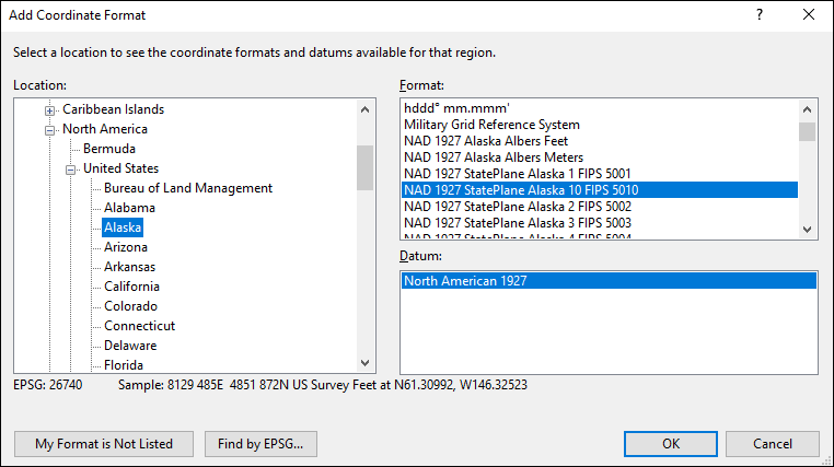
To add a coordinate format in ExpertGPS, click Preferences on the Edit menu, and click on the My Coordinate Formats tab. Click Add. The Add Coordinate Format dialog will appear. On the left is an expandable list of all of the continents, countries, and US states. As you expand the location tree, ExpertGPS will show the coordinate formats used in that region on the right side of the dialog. Drill-down in the location side as far as you need to go to see the coordinate format for your location. Select the coordinate format, and then choose the appropriate datum from the list below.
Step 2: Add or import your data
You can add waypoints by hand, draw waypoints or tracks on the map, receive data from your GPS, or import it into ExpertGPS from KML, CSV, a shapefile, CAD drawing, or other mapping format.
Step 3: Select your output coordinate format
As soon as you switch to your output coordinate format by selecting it from the My Coordinate Formats list, ExpertGPS will reproject all of your data to the new format and datum. Your data is converted, and ready for use. You can export it to another mapping, CAD, or GIS program, or copy and paste it into Excel.
Three easy steps, and your coordinates have been converted
ExpertGPS makes coordinate conversion quick, easy, and accurate
New features were added to ExpertGPS on May 1, 2026
ExpertGPS runs on Windows 11 and Windows 10.
Solutions to Common Coordinate Conversion Problems
Most problems involving GPS and map coordinate mis-matches are due to choosing the incorrect coordinate format and datum at some point in the process. If you are entering GPS coordinates by hand into ExpertGPS from a book or a Web page, you need to ensure that you've selected the same coordinate format and datum that the source's author used, or position errors will occur.
There are four main types of coordinate formats used throughout the world today: lat/lon, UTM, US State Plane, and National Grids.
Lat/lon coordinates:
There are three different ways to express latitude and longitude:
1. decimal degrees. (42.12345ºN, -71.23456ºW) Note that there are no
spaces in these coordinates.
2. degrees and minutes (42º 23.456'N, -71º 43.632'W) Marine, aviation,
and geocaching coordinates are usually given in deg min.min format.
Note that there is a space between the degrees (º) and the minutes (')
part of the coordinates.
3. degrees, minutes, and seconds. (42º 34' 54.234"N, -71º 24'
14.234"W) Civil survey and some marine waypoints are given in this
format. Note that there are three parts to each coordinate, separated
by spaces, and that three symbols are used to show the degrees,
minutes, and seconds (º ' ").
UTM coordinates
Universal Transverse Mercator (UTM) coordinates are used worldwide. Unlike lat/lon, which is a spherical coordinate system based on angles, UTM, state plane, and national grid coordinates are rectangular grid systems where coordinates are expressed as Northings and Eastings from a fixed reference point. Rectangular grids make it much easier to calculate distances and to plot locations on a rectangular map. UTM coordinates look like this: 2346212N, 12343523E, 18T. The first value is the Northing. The second is the Easting. The third value (always a number between 1 and 60 followed by a single letter) is the UTM zone identifier. If your data is in UTM coordinates, it is very likely in NAD27 datum or WGS84 datum (see below). The vast majority of UTM data is expressed in meters. If you are using UTM data collected prior to 1983 by a US state entity, there's a chance that it uses US Survey Feet rather than meters as the base unit. ExpertGPS Pro provides an option for UTM coordinates in feet.
US State Plane Coordinates
Almost all of the data available from US state government Web sites is
expressed in the US State Plane Coordinate System. US SPCS coordinates
have two values, a Northing and an Easting. Some US states have only a
single SPCS zone. Other states have a handful, broken down by county.
You'll need to know which zone is in use, and select the correct one
in ExpertGPS Pro. This Web page lists the counties in every
US state, and the appropriate SPCS zone to use:
Converting and Using US State Plane Coordinates with ExpertGPS Pro
National Grids
Outside of the United States, many countries have their own National Grid coordinate systems. Many of these use the same Northing, Easting format described above. ExpertGPS lists the national grids for each country in the Add Coordinate Format dialog.
To add a coordinate format in ExpertGPS, click Preferences on the Edit menu, and click on the My Coordinate Formats tab. Click Add. The Add Coordinate Format dialog will appear. On the left is an expandable list of all of the continents, countries, and US states. As you expand the location tree, ExpertGPS will show the coordinate formats used in that region on the right side of the dialog. Drill-down in the location side as far as you need to go to see the coordinate format for your location. Select the coordinate format, and then choose the appropriate datum from the list below.
In the United States, you have two main datum choices: NAD27, and NAD83/WGS84. NAD27 was used from 1927 up until 1983, when it was replaced by NAD83 and WGS84. You can consider NAD83 and WGS84 to be identical in the 50 United States.
For other areas of the world, ExpertGPS will display the datums used in that region. Select the correct datum from the list.
You can add many different coordinate formats to ExpertGPS, and switch between them at any time to enter data or convert data to another format. ExpertGPS Pro users should keep in mind that the currently-active coordinate format is used whenever you import and export data.
Help with Coordinate and Datum Conversion
For more information on datums and coordinate formats in ExpertGPS, visit these Web pages:
- ExpertGPS Help: Why don't my coordinates match?
- ExpertGPS Help: The Edit Coordinates Dialog
- Converting and Using US State Plane Coordinates with ExpertGPS Pro
New features were added to ExpertGPS on May 1, 2026
ExpertGPS runs on Windows 11 and Windows 10.
GPS Support
© 1998-2026 TopoGrafix – 24 Kirkland Dr, Stow, MA – Email: support@expertgps.com