Send Map to GPS Command
If your Garmin GPS receiver supports Custom Maps, the Send Map to GPS command in ExpertGPS can send any map or aerial photo to your GPS so you can use it to determine your exact location in the field.
To send a custom map to your Garmin GPS, do the following:
- Recenter the map so that your area of interest is in the center of the screen.
- Zoom in or out to the level of detail you would like to see on your GPS.
- On the , click .
The Send Map to GPS dialog will appear, allowing you to customize the size and scale of the custom map. The scale of the Custom Map will be set to the current scale of the map in ExpertGPS. It may help to zoom out now and adjust the Width and Height values until the preview rectangle covers your area of interest.
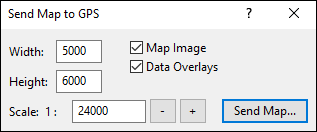
- Width
- Enter the width of the image.
- Height
- Enter the height of the image.
- Scale
- Enter the map scale of the image. This will already be set to the current scale of the map in ExpertGPS.
- Send Map
- Click Send Map to create the custom map and save it to your GPS.
Click to begin sending the custom map to your GPS. A dialog with instructions on where to save the Custom Map and how to copy it to your Garmin GPS will appear. Then the Save As dialog will appear. Save the custom map to your desktop. The map is in .kmz format, and you can double-click the .kmz file to preview the map in Google Earth. When you are satisfied with the Custom Map, copy the .kmz file to the Garmin/CustomMaps folder on your GPS. If your GPS has a microSD card, that is the preferred location. Copy the Custom Map to (microSD Card drive)/Garmin/CustomMaps/ instead of (Garmin device drive)/Garmin/CustomMaps/.
After you are finished sending your custom map, do one of the following:
- On the , click .
- Click the close box on the Send Map to GPS window.
© 1998-2026 TopoGrafix – 24 Kirkland Dr, Stow, MA – Email: support@expertgps.com