Here’s a legal description of an actual parcel somewhere in the south – I’ve been using this as a test case:
Beginning at a point; thence S82°08'58"E, 666.90' to a point; thence S55°27'34"W,116.29' to a point; thence S64°05'57"W, 217.03' to a point; thence S73°35'56"W,107.97' to a point; thence N64°53'20"W, 187.07' to a point; thence N25°28'12"W,224.77' to the point of beginning; containing 2.032 acres of land.
Wouldn’t it be nice to be able to just paste that into ExpertGPS and have it plotted automatically on the map? That’s the goal, and I’m developing a new Import Legal Description wizard to accomplish just that. Here’s an early prototype:
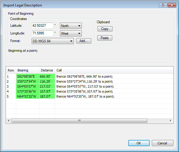
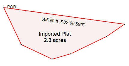
I just copy and paste the entire legalese right into the Route List. Normally this would bring up the Import Text wizard, but ExpertGPS now knows that if your text contains phrases like “Beginning at a point” and “thence”, you must be importing a series of survey calls. Up comes the new dialog, and ExpertGPS scans your text and automatically separates it into individual calls. Each individual call is scanned, and ExpertGPS tries to pick out the bearing and distance from the text. If it is successful, that call is displayed in green. If there’s a typo or something that ExpertGPS can’t parse, you’ll be able to enter the distance or bearing manually. Once all the calls are green, the OK button lights up and all you have to do is click it. Oh, you also have to tell ExpertGPS where the Point of Beginning is, either by entering coordinates, or (coming soon) by selecting a waypoint. You can see the resulting parcel as displayed in ExpertGPS.
I still need to add support for curves and run as many test cases as I can find. This feature is in active development, so please send me an email or enter a comment below if you’ve got questions or suggestions.
Just to be clear: unless you are a licensed land surveyor, you should not be creating your own land “surveys”. Just because a tool like ExpertGPS exists that will let you compute distances and bearings between points doesn’t mean that you can create a legal survey of your property. ExpertGPS is a great tool for mapping old property descriptions or for assisting in the search for your property corner markers. But if you’re going to be buying or selling property or making decisions based on property boundaries, you need a professional – a licensed land surveyor.
This is an awesome feature! I have been wanting this kind of tool for a long time. I’ll offer a good land description that has curves described by radius, chord length, arc distance and chord bearing, as well has having a point of tangency in the description, if it will help out.
I have a several year old Garmin. I purchased about 3.5 Ac with typical property description except several data points are given in terms such as following the railroad right of way (slight curve & no one seems to be exactly sure how wide the right of way is, but in two spots I can measure from ageing surveyor flag to apx center of raised gravel abandoned railway track) and “following the waters edge” (a curvilinear State’s waters interface on an adjoining side). Still, several datum are related to Quad Map TSR. The property is shaped like a crescent moon with several angles and runs given precisely in degrees and ft. I also have MapQuest and DeLorme map pgms. Would your software be an improvement?
Tks, Dave Carty
David, ExpertGPS Pro will help if you have complete calls (bearing and distance) for each call in the legal description. Normally when a water course or railroad ROW is followed, the surveyor still lists a distance and bearing along that course so that you can still compute the boundary even if the river shifts.
If there’s one call missing information, you could work backwards, keeping the distances the same, but swapping North for South and East for West in the bearings (this is how you create a back bearing) until you reach the boundary along the water from both directions.
Here’s a comment I received from an ExpertGPS customer who works as a licensed land surveyor. Please remember that when you use ExpertGPS or any other mapping tool that there are some jobs that are best left to the professionals.
“Hey, I just saw on your web page that you are working on a
routine to plot an existing deed from the bearings and distances. There
is nothing wrong with that, but BE CAREFUL about adding the reverse
function. I am a licensed land surveyor and it is extremely dangerous to
let the public think they can run out with their hand held GPS, “locate”
the corners of what they think is their property, and then create a
legal description (using your software) to create a deed for sale. If it
were that simple then I would not have a job! Locating boundaries is as
much, or more, a matter of law, than just the physical measurements. I’m
also ignoring the fact that the measurements with a consumer grade GPS
are no where near adequate to locate boundaries. If you add this reverse
routine, someone will do exactly as I just said and try to do their own
“survey”. That’s kind of like trying to do your own dental work… not a
good idea!”
I certainly hope that you will be able to do this. I am trying to find some old bounds in the woods and this would certainly make those searches much easier.
The ‘gold standard’ for working with legal descriptions is Net Deed Plotter (https://www.deedplot.com/). There is a full-featured free trial.
Ok, this appeares to be a basic COGO (coordinate geometry) program, copy and paste is a quick way to enter your data. Here’s the problem, most deeds do not reference in any way a beginning coordinate, therefore your P.O.B is unknown. Yes you can enter bearing and distance around parcel and end up with a closed figure but that figure could be anywhere on the face of the earth. (Solution) You must find the phisical P.O.B. ie; “Beginning at a CONCRETE MONUMENT on the north side of the highway at the south east corner of the lands of Albert thence N36*21’36″E 1256.06′ to an IRON PIPE at the North East corner of the lands of Albert etc:—–Once you find that “Concrete Monument” establish a coordinate on the monument. (This is best left to a SURVEYOR!!!!!) but for this discussion, use your hand held and “MARK” the top of the monument, You now know where your P.O.B. lies on the face of the earth.
Problem 2: The bearings on these deeds are not likely to be “relative” to your GPS datum ie; WGS84 they could be magnetic north, a compass bearing, or unknown etc. etc. Therefore your bearings could be SEVERAL DEGREES OFF.
(SOLUTION) Find the next PHISICAL MARKER ie; “to an IRON PIPE at the north east corner of the lands of Albert” use your GPS to “MARK” the top of the IRON PIPE, you now know the bearing between the PHISICAL MARKERS relative to your GPS datam. You can now ROTATE your pojected deed description around your KNOWN COORDINATES of the concrete monument useing the deeded line {thence N36*21’36″E 1256.06 to an iron pipe} as your REFERENCE LINE to the known bearing of your phisical IRON PIPE,(note: all the bearings of your projected deed should change by the same amount) your deed is now “RELATIVE” to your “GPS DATUM”!!!!! This is what I would like the ability to do in Expertgps “Rotate a shape, track, route etc. around a point by a reference line, to a point or to another reference line.
This discription in no way constitutes a boundary survey but will be sufficient to walk around your property and find the PHISICAL MARKERS with your hand held.
PLEASE PLEASE PLEASE leave the surveying and deed descriptions to the SURVEYORS and LAWYERS!!!!!
When can we expect the legal land description import to be available?