Stacy X. asks:
![]() What is the best method to create a gpx or kml file of an area filled polygon that has islands (a lake shp file). When I export as a gpx, it creates a polyline where the end node of the lake outline connects to the end nodes of each of the islands. When I export as a kml, the fill of the polygon is not complete. The strange part is when you zoom in, the lake polygon will fill; then if you zoom out, it empties.
What is the best method to create a gpx or kml file of an area filled polygon that has islands (a lake shp file). When I export as a gpx, it creates a polyline where the end node of the lake outline connects to the end nodes of each of the islands. When I export as a kml, the fill of the polygon is not complete. The strange part is when you zoom in, the lake polygon will fill; then if you zoom out, it empties.![]()
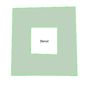
ExpertGPS Pro allows you to draw, view, and import polygons with complex geometry, including filled objects with holes in them. You can use this feature to draw lakes with islands,
a park boundary with private land inholdings, or other complex shapes. Here’s how to create the “donut” shown at right.
Begin by drawing the outer shape, using the shape tool. I clicked to draw the four corners, and then pressed Enter to finish the drawing and connect the fourth corner back to the start. (This happens automatically when you select a filled shape type)
I then drew the inner hole using the shape tool. Add the shape points in counter-clockwise order! This is important – most GIS and 3D systems consider counter-clockwise polygons to be inner holes.
Once the two shapes are drawn, select both by clicking the outer one with the Select tool, holding Shift, and selecting the inner one (or ones, if there are multiple holes). Right click, and click Join Shapes to convert the selected shapes into one composite shape. ExpertGPS will recognize the inner holes and leave them unfilled. If you calculate area, ExpertGPS will subtract out the area of any inner polygons, giving you the correct acreage of your lake or property.
You can now export the shape to your GIS software in shapefile format, or click View in Google Earth to see the lake or property boundary over the aerial imagery in Google Earth.