Tom H. asks:
![]() I need a software mapping program that will allow me to draw a circle of varying radius and tell me how many acres in that circle.
I need a software mapping program that will allow me to draw a circle of varying radius and tell me how many acres in that circle.![]()
How do I Draw a Circle on a Map and Calculate its Acreage?
The formula for the area of a circle is: Area = π * radius². If the radius is given in feet, the area is in square feet. To convert from square feet to acres, divide by 43560. So the acreage of a circular area is: Acres = π * radius_in_feet² / 43560.
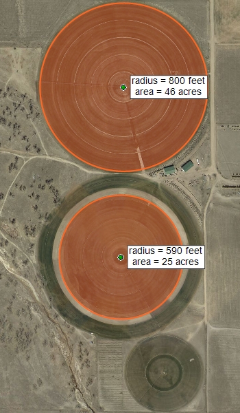
Drawing Circles on the Map
ExpertGPS can draw a circle of any radius around a waypoint. Edit the waypoint, and enter the circle radius in the Proximity field. Waypoint Proximity is used by some Garmin GPS receivers to sound an alarm when you come within the proximity distance. Mariners use proximity waypoints to mark rocks, wrecks, and other obstructions in the waterway, so that their GPS will alert them if they approach these hazards too closely. You can make use of the Proximity circles in ExpertGPS to map out center-pivot irrigation systems for your farm, check the coverage of wireless or communications towers, or determine the service area of a store or business, fire station, or police station.
Related Topics
Ask the GPS Expert: How do I calculate the acreage of an irregularly-shaped farm field?
Calculating the acreage of any parcel with ExpertGPS.
ExpertGPS Help File: Calculating Area