Geotag Photos Dialog
The Geotag Photos dialog allows you to place your digital photos on the map, by matching the photo timestamps with the timestamps recorded in your GPS tracklog.
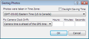
- Time Zone
- Select the time zone where the photos were taken. Set the Daylight Saving Time checkbox based on whether or not DST was in effect when the photos were taken.
- Fix Camera Clock Drift
- If you synchonize your camera's clock to the time displayed on your GPS each time you photograph, you'll never need to use this setting. If you forget to do it, however, there's still hope. Look at the time on both your camera and your GPS, and figure out which one is ahead of the other, and by how much. Enter those values here, and ExpertGPS will take this correction into account when geotagging your photos.
Related Topics
© 1998-2026 TopoGrafix – 24 Kirkland Dr, Stow, MA – Email: support@expertgps.com