Grid Builder Command
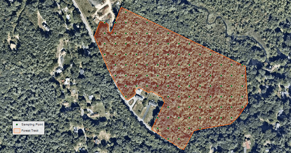
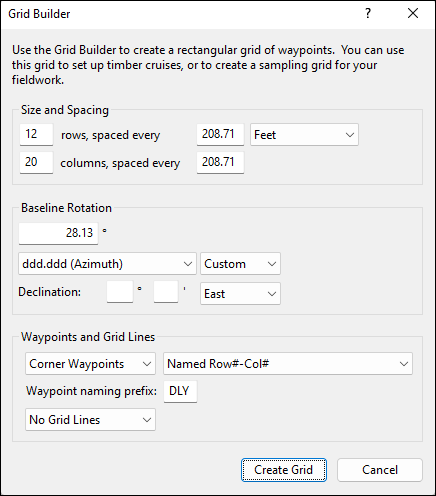
The Grid Builder command allows you to create evenly-spaced grids of waypoints, perfectly suited for timber cruises or collecting sample data. The Grid Builder dialog can be invoked from a starting waypoint or from a closed shape (like the outline of a forest tract) - select a waypoint or shape on the map, right-click, and click Grid Builder. From this initial point, you can then specify the height and width of each "cell" in the grid, and choose how many rows and columns will make up the grid. As you enter information, ExpertGPS draws a preview grid on the map. You can switch back and forth between the dialog and the map, which is helpful if you need to zoom in or out, or pan the map around.
Baseline Rotation allows you to rotate the entire grid clockwise, to align with a edge of the parcel. The default zero rotation builds the grid up and to the left, and works well for a starting waypoint in the lower left (SW) corner of the parcel.
ExpertGPS offers several options for how the grid of sampling waypoints in created and named. You can choose to have the grid numbered sequentially by row (left to right) or by column (bottom to top). You can also create a zig-zag route of waypoints, going left to right across the first row, and then right-to-left across the second row, and continuing to alternate direction. This is helpful if you are flying a drone or walking to each successive sampling point in sequence. Finally, you can have each waypoint labelled according to its position in the grid, using a ROW#-COL# format. You can add a short prefix to all of the waypoints created for this grid, so you can keep all of the sampling points for a specific parcel together.
In addition to creating a waypoint grid, the Grid Builder command can also outline the grid boundaries by creating Grid Squares or Grid Lines. If you select Grid Squares, ExpertGPS will create a checkerboard pattern of squares that outline each cell. Each cell is a single track, and the Track Type attribute for each track alternates between "Grid Square 1" and "Grid Square 2".
To build a grid of waypoints for a timber cruise or to create a rectangular sampling cell, do the following:
- Select a single waypoint or a closed (polygon) shape.
-
Then, do one of the following:
- On the , click .
- Right-click on the selected waypoint or polygon shape, and click .
© 1998-2026 TopoGrafix – 24 Kirkland Dr, Stow, MA – Email: support@expertgps.com