Convert France Coordinates in a Single Click
Using ExpertGPS as a French GPS, GIS, and CAD Coordinate Converter
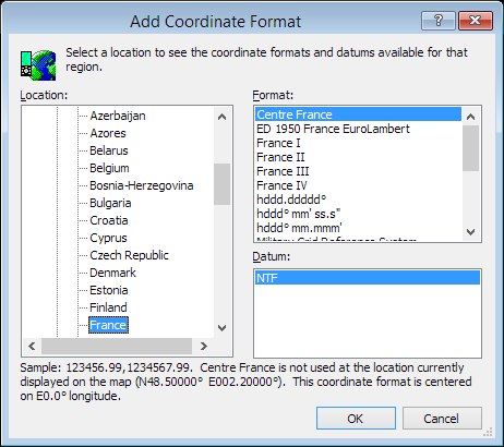
With just a single click, you can do French datum conversions or re-project entire files of coordinate data between French coordinate formats. ExpertGPS supports all of the coordinate formats used in France, including RGF 1993 Lambert 93, ED 1950 France EuroLambert, RGF 1993 CC42, RGF 1993 CC43, RGF 1993 CC44, RGF 1993 CC45, RGF 1993 CC46, RGF 1993 CC47, RGF 1993 CC48, RGF 1993 CC49, RGF 1993 CC50, NTF France I degrees, NTF France II degrees, NTF France III degrees, NTF France IV degrees, NTF Lambert Zone I, NTF Lambert Zone II, NTF Lambert Zone III, NTF Lambert Zone IV, UTM, and latitude and longitude.
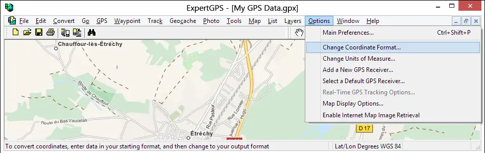
You can convert your GPS, GIS, or CAD data to any of these formats by bringing it into ExpertGPS and then selecting Change Coordinate Format... on the Options menu in ExpertGPS. Your data is instantly reprojected to the new datum and coordinate format.
Even if your GPS doesn't support the coordinate grid format you use for a project at work, you can use ExpertGPS to seamlessly move your data between your GPS and your workstation, reprojecting the data on-the-fly to match the coordinate system you use in AutoCAD or ArcGIS. ExpertGPS also creates Excel CSV and Google Earth KML files so you can create reports or view your coordinate data over high-resolution aerial imagery and GPS maps of France.
ExpertGPS Converts Between Any of These French Coordinate Formats:
- hddd.ddddd° (Lat/Lon Degrees)
- hddd° mm.mmm' (Lat/Lon Degrees & Minutes)
- hddd° mm' ss.s" (Lat/Lon Deg. Min. Sec.)
- Universal Transverse Mercator (UTM)
- Military Grid Reference System (MGRS)
- RGF 1993 Lambert 93 - EPSG 2154
- ED 1950 France EuroLambert - EPSG 2192
- RGF 1993 CC42 - EPSG 3942
- RGF 1993 CC43 - EPSG 3943
- RGF 1993 CC44 - EPSG 3944
- RGF 1993 CC45 - EPSG 3945
- RGF 1993 CC46 - EPSG 3946
- RGF 1993 CC47 - EPSG 3947
- RGF 1993 CC48 - EPSG 3948
- RGF 1993 CC49 - EPSG 3949
- RGF 1993 CC50 - EPSG 3950
- NTF France I degrees - ESRI 102581
- NTF France II degrees - ESRI 102582
- NTF France III degrees - ESRI 102583
- NTF France IV degrees - ESRI 102584
- NTF Lambert Zone I - ESRI 102585
- NTF Lambert Zone II - ESRI 102586
- NTF Lambert Zone III - ESRI 102587
- NTF Lambert Zone IV - ESRI 102588
ExpertGPS Reprojects Your Data Between Any of These Datums:
- World Geodetic System 1984 (WGS 84) - EPSG 4326
- World Geodetic System 1972 (WGS 72) - EPSG 4322
- ETRS 1989 - EPSG 4258
- European 1950, Mean (7 Param) (European 1950) - EPSG 4230
- European 1979
- RGF 1993 - EPSG 4171
- NTF - EPSG 4275
New features were added to ExpertGPS on May 1, 2026
ExpertGPS runs on Windows 11 and Windows 10.
© 1998-2026 TopoGrafix – 24 Kirkland Dr, Stow, MA – Email: support@expertgps.com