Photo Viewer Options Dialog

Photo Viewer Options dialog

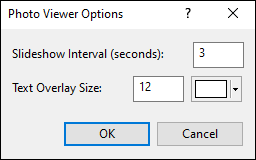
The Photo Viewer Options dialog controls how text is displayed in the Photo Viewer, and allows you to change the interval between photos in the slideshow.

Slideshow Interval
Enter the number of seconds to show the photo before advancing to the next photo in the slideshow.
Text Overlay
Enter the size and color of the overlay text.


ExpertGPS is GPS mapping software designed to work seamlessly with your Garmin, Magellan, Eagle, or Lowrance GPS receiver. ExpertGPS makes it easy to view waypoints and GPS tracklogs over USGS topo maps, aerial photos, and color orthophotos. ExpertGPS Pro can send GPS data to and from ArcView GIS and AutoCAD DXF and dozens of other standard file formats.


Return to Getting Started with ExpertGPS Map Software

Visit the ExpertGPS Homepage

Find your GPS on the Mapping Software for GPS compatibility page

Download a free trial of ExpertGPS map software (30 day demo, fully-featured)


Purchase ExpertGPS map software with a credit card, PayPal, or purchase order

$59.95 ExpertGPS Home

$159.95 ExpertGPS Pro

Compare Versions


Download a free trial of ExpertGPS map software (30 day demo, fully-featured)

GPS Map Software
for Windows 7, Vista & XP


New features added
March 8, 2010


GPS Support

ExpertGPS works with:

  • ExpertGPS is Garmin GPS Map Software
  • ExpertGPS is Magellan GPS Map Software
  • ExpertGPS is Lowrance GPS Map Software
  • ExpertGPS is Eagle GPS Map Software

Find your GPS model:


Copyright 1998-2009 TopoGrafix – 24 Kirkland Dr, Stow, MA – Email: Fax Orders: (815) 346-5239