Convert Canada Coordinates in a Single Click
Using ExpertGPS as a Canadian GPS, GIS, and CAD Coordinate Converter
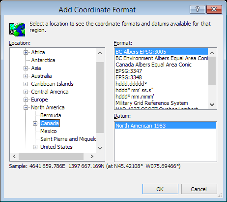
With just a single click, you can do Canadian datum conversions or re-project entire files of coordinate data between Canadian coordinate formats. ExpertGPS supports all of the coordinate formats used in Canada, including NAD 1983 Ontario MNR Lambert (NAD83 Ontario MNR Lambert), NAD 1983 Statistics Canada Lambert (NAD83 Statistics Canada Lambert), NAD 1983 10TM AEP Forest (NAD83 10TM AEP Forest), NAD 1983 10TM AEP Resource (NAD83 10TM AEP Resource), NAD 1983 Northwest Territories Lambert (NAD83 Northwest Territories Lambert), NAD 1927 3TM 111 (NAD27 3TM 111), NAD 1927 3TM 114 (NAD27 3TM 114), NAD 1927 3TM 117 (NAD27 3TM 117), NAD 1983 3TM 111 (NAD83 3TM 111), NAD 1983 3TM 114 (NAD83 3TM 114), NAD 1983 3TM 117 (NAD83 3TM 117), NAD 1927 MTQ Lambert (NAD27 MTQ Lambert), NAD 1983 MTQ Lambert (NAD83 MTQ Lambert), NAD 1927 3TM 120 (NAD27 3TM 120), NAD 1983 3TM 120 (NAD83 3TM 120), NAD 1983 Canada Atlas Lambert (NAD83 Canada Atlas Lambert), NAD 1983 Teranet Ontario Lambert (NAD83 Teranet Ontario Lambert), NAD 1927 Quebec Lambert (NAD27 Quebec Lambert), NAD 1983 Quebec Lambert (NAD83 Quebec Lambert), Canada Lambert Conformal Conic, NAD 1927 10TM AEP Forest (NAD27 10TM AEP Forest), NAD 1927 10TM AEP Resource (NAD27 10TM AEP Resource), WGS 1984 Canada Atlas LCC (WGS84 Canada Atlas LCC), UTM, and latitude and longitude.
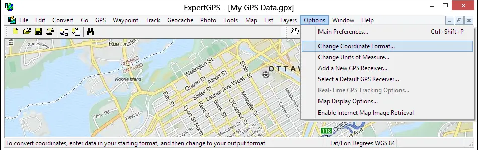
You can convert your GPS, GIS, or CAD data to any of these formats by bringing it into ExpertGPS and then selecting Change Coordinate Format... on the Options menu in ExpertGPS. Your data is instantly reprojected to the new datum and coordinate format.
Even if your GPS doesn't support the coordinate grid format you use for a project at work, you can use ExpertGPS to seamlessly move your data between your GPS and your workstation, reprojecting the data on-the-fly to match the coordinate system you use in AutoCAD or ArcGIS. ExpertGPS also creates Excel CSV and Google Earth KML files so you can create reports or view your coordinate data over high-resolution aerial imagery and GPS maps of Canada.
ExpertGPS Converts Between Any of These Canadian Coordinate Formats:
- hddd.ddddd° (Lat/Lon Degrees)
- hddd° mm.mmm' (Lat/Lon Degrees & Minutes)
- hddd° mm' ss.s" (Lat/Lon Deg. Min. Sec.)
- Universal Transverse Mercator (UTM)
- Military Grid Reference System (MGRS)
- NAD 1983 Ontario MNR Lambert (NAD83 Ontario MNR Lambert) - EPSG 3161
- NAD 1983 Statistics Canada Lambert (NAD83 Statistics Canada Lambert) - EPSG 3347
- NAD 1983 10TM AEP Forest (NAD83 10TM AEP Forest) - EPSG 3400
- NAD 1983 10TM AEP Resource (NAD83 10TM AEP Resource) - EPSG 3401
- NAD 1983 Northwest Territories Lambert (NAD83 Northwest Territories Lambert) - EPSG 3580
- NAD 1927 3TM 111 (NAD27 3TM 111) - EPSG 3771
- NAD 1927 3TM 114 (NAD27 3TM 114) - EPSG 3772
- NAD 1927 3TM 117 (NAD27 3TM 117) - EPSG 3773
- NAD 1983 3TM 111 (NAD83 3TM 111) - EPSG 3775
- NAD 1983 3TM 114 (NAD83 3TM 114) - EPSG 3776
- NAD 1983 3TM 117 (NAD83 3TM 117) - EPSG 3777
- NAD 1927 MTQ Lambert (NAD27 MTQ Lambert) - EPSG 3797
- NAD 1983 MTQ Lambert (NAD83 MTQ Lambert) - EPSG 3798
- NAD 1927 3TM 120 (NAD27 3TM 120) - EPSG 3800
- NAD 1983 3TM 120 (NAD83 3TM 120) - EPSG 3801
- NAD 1983 Canada Atlas Lambert (NAD83 Canada Atlas Lambert) - EPSG 3978
- NAD 1983 Teranet Ontario Lambert (NAD83 Teranet Ontario Lambert) - EPSG 5320
- NAD 1927 Quebec Lambert (NAD27 Quebec Lambert) - EPSG 32098
- NAD 1983 Quebec Lambert (NAD83 Quebec Lambert) - EPSG 32198
- Canada Lambert Conformal Conic - ESRI 102002
- NAD 1927 10TM AEP Forest (NAD27 10TM AEP Forest) - ESRI 102178
- NAD 1927 10TM AEP Resource (NAD27 10TM AEP Resource) - ESRI 102179
- WGS 1984 Canada Atlas LCC (WGS84 Canada Atlas LCC) - ESRI 102215
ExpertGPS Reprojects Your Data Between Any of These Datums:
- World Geodetic System 1984 (WGS 84) - EPSG 4326
- World Geodetic System 1972 (WGS 72) - EPSG 4322
- North American 1927 (NAD27) - EPSG 4267
- North American 1983 (NAD83) - EPSG 4269
- North American 1983, HARN (NAD83 HARN) - EPSG 4152
- North American 1983, CORS96 (NAD83 CORS96) - ESRI 104223
- North American 1927, Canada (NAD27 Canada)
- North American 1927, Alberta/BC (NAD27 AB/BC)
- North American 1927, E. Canada (NAD27 E. Canada)
- North American 1927, Man/Ont (NAD27 MB/ON)
- North American 1927, NW Terr. (NAD27 NT)
- North American 1927, Yukon (NAD27 YT)
New features were added to ExpertGPS on April 15, 2024
ExpertGPS runs on Windows 11 and Windows 10.
© 1998-2024 TopoGrafix – 24 Kirkland Dr, Stow, MA – Email: support@expertgps.com