USGS Topo Maps Make Your Next Hiking Trip a Success!
Hike with Confidence - Hike with ExpertGPS!
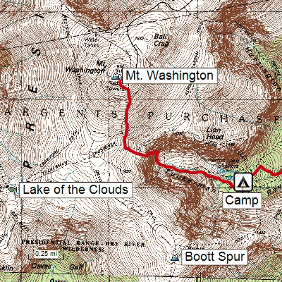
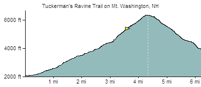
Hikers, hunters, and other outdoor enthusiasts depend on the USGS topographical maps and seamless aerial photography in ExpertGPS to plan their outings, and to guide them home safely. Zoom right in on any topo map - see just how steep the trail ahead will be. Draw a safe route by clicking on the map, and send it to your GPS to guide you along your way. When you get back home, play back your recorded GPS tracklog and see a map of your exact route, along with an elevation profile showing your ascent and descent.
Hiking maps for the entire US
Download now and start your free trial of ExpertGPS 8.63
New features were added to ExpertGPS on April 15, 2024
ExpertGPS runs on Windows 11 and Windows 10.
New features were added to ExpertGPS on April 15, 2024
ExpertGPS runs on Windows 11 and Windows 10.
Who uses ExpertGPS?
- The Nature Conservancy
- Mill Valley Snowmobile Club
- US Fish & Wildlife Service
- Wolf Creek Hunting Club
- Bureau of Land Management
- Northern Hardwoods
- Pennington Seed
- Ford Motor Company
- US Forest Service
- Plum Creek Timber Co.
- University of Wyoming
- Union Pacific Railroad
- San Ramon Valley Fire District
- American River College
- LPG Environmental
- Peters Forest Resources
- and many more...
© 1998-2024 TopoGrafix – 24 Kirkland Dr, Stow, MA – Email: support@expertgps.com