Convert Iowa North State Plane Coordinates in NAD27 to/from UTM, lat / long
ExpertGPS Pro mapping software automatically converts Iowa North FIPS 1401 coordinates to and from any other coordinate format or datum, including UTM, lat/lon, and other Iowa state plane coordinate formats, in NAD27, NAD83, and WGS84. ExpertGPS Pro instantly converts GIS shapefiles and CAD DXF drawings in Iowa state plane coordinates to and from UTM or lat-long.
Iowa North FIPS 1401 Geographic Coverage
Iowa North covers these Iowa counties: Allamakee, Benton, Black Hawk, Boone, Bremer, Buchanan, Buena Vista, Butler, Calhoun, Carroll, Cerro Gordo, Cherokee, Chickasaw, Clay, Clayton, Crawford, Delaware, Dickinson, Dubuque, Emmet, Fayette, Floyd, Franklin, Greene, Grundy, Hamilton, Hancock, Hardin, Howard, Humboldt, Ida, Jackson, Jones, Kossuth, Linn, Lyon, Marshall, Mitchell, Monona, O'brien, Osceola, Palo Alto, Plymouth, Pocahontas, Sac, Sioux, Story, Tama, Webster, Winnebago, Winneshiek, Woodbury, Worth, Wright
Working with Iowa North State Plane Coordinates
The first step in working with or converting Iowa North FIPS 1401 state plane coordinates in ExpertGPS is to add the appropriate coordinate format and datum for your project. On the Edit menu in ExpertGPS, click Preferences. Click on the My Coordinate Formats tab, and click the Add Format button.
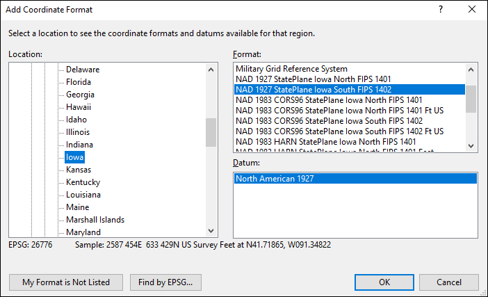
In the Add Coordinate Format dialog, change the Location, on the left side of the dialog, to World/North America/United States/Iowa. A list of all of the coordinate formats used in Iowa will appear in the Format pane in the upper right. Select Iowa North FIPS 1401, Meters, (or Feet, if you want to use US Survey Feet as the base unit). Now select NAD83 or NAD27 in the lower right pane, labelled Datum. (Note: WGS84 is identical to NAD83 in Iowa, so select the NAD 83 datum if you are trying to convert from WGS84 state plane coordinates.)
Converting IA North to UTM
You can use ExpertGPS Pro as a Iowa state plane to UTM converter. Here's how to convert Iowa North coordinates to UTM:
First, add the IA North SPCS, as described above.
Enter your data in Iowa North, paste it in from Excel, or import a shapefile or CAD drawing by clicking Import on the File menu. ExpertGPS Pro will convert your state plane coordinates and display them over a topo map or aerial photo of Iowa.
Now add the UTM coordinate format and datum of your choice by returning to the Add Coordinate Format dialog. When you select UTM in the My Coordinate Formats list, all of your data will instantly be reprojected from Iowa state plane to UTM.
You can now export the reprojected UTM data by clicking Export on the File menu, or copy and paste into a spreadsheet.
How to Convert Iowa State Plane Coordinates to Lat / Long
Follow the instructions above, but instead of choosing UTM as your output format, choose one of ExpertGPS Pro's latitude and longitude formats. ExpertGPS can convert your Iowa North coordinates to lat-lon in decimal degrees, degrees and minutes (deg min.min), or degrees, minutes, and seconds (DMS).
New features were added to ExpertGPS on April 15, 2024
ExpertGPS runs on Windows 11 and Windows 10.
Sending Iowa North coordinates to your Garmin or Magellan GPS
Your GPS receiver can't display your location using the US state plane coordinate system, but you can use ExpertGPS Pro to send X,Y points or polyline data from your GIS or CAD software to your GPS receiver. Import or enter your data as described above. There's no need to select an output format like UTM or lat/long, unless you want ExpertGPS to display the same values that will be displayed on your GPS. Just click Send to GPS on the GPS menu. ExpertGPS will reproject the Eastings and Northings in your Iowa North coordinates into the native format used by your GPS receiver, and upload them directly to the GPS. Now you can view all of your GIS or CAD data in the field on any Garmin, Magellan, Lowrance, or Eagle GPS!
Viewing Iowa North State Plane GIS Data in Google Earth
Another option you have once you've imported GIS or CAD data in IA North SPCS into ExpertGPS is to convert it to KML or view it directly in Google Earth. To convert state plane to KML, simply click Export on the File menu, and select the Google Earth KML file type. If you just want to view your IA North SPCS data in Google Earth, simply press F7, the View in Google Earth command in ExpertGPS.
Using ExpertGPS as a UTM to Iowa North Converter
Add the UTM coordinate format to ExpertGPS, and then import or enter your UTM data. To convert UTM to state plane, add and select the Iowa SPCS, as described above, and your UTM Northings and Eastings will be converted to state plane coordinates.
Converting lat/lon or GPS data to Iowa North
Use the technique above to convert latitude and longitude data to Iowa Northings and Eastings. To convert Garmin, Magellan, or Lowrance GPS waypoints or tracks to Iowa North state plane is even easier - just click Receive from GPS. ExpertGPS Pro automatically reprojects your GPS data into whatever coordinate format you select: Iowa state plane, UTM, or lat/long. You can then export your reprojected data into a GIS in shapefile format, export a DXF for your CAD software, or copy and paste into Excel or a CSV file.
How to Display Iowa North Coordinates on your GPS
Most handheld GPS receivers can't display Iowa state plane coordinates natively. But if you've got an older Magellan GPS receiver that allows you to set up a User Grid (check your GPS manual for compatibility), you can use the settings for the Iowa North Transverse Mercator projection listed below to trick your GPS into displaying Iowa coordinates in meters. On Magellan GPS receivers, go to the SETUP screen, and then click COORD SYSTEM, PRIMARY, USER GRID. If you want to use US Survey Feet instead of Meters, click UNITS TO METERS CONV and enter 0.30480061.
Iowa North FIPS 1401 Parameters (NAD27 Datum)
| Deg Min.Min | Decimal Degrees | |
| Central Meridian | -93° 30' | -93.50° |
| Latitude of Origin | 41° 30' | 41.50° |
| Standard Parallel #1 | 42° 04' | 42.07° |
| Standard Parallel #2 | 43° 16' | 43.27° |
| False Easting | 2000000 meters | |
| False Northing | 0 meters | |
Iowa North uses a Lambert Projection.
Download ExpertGPS Pro: your Iowa North State Plane Converter
ExpertGPS makes it easy to convert coordinates to and from lat/lon, UTM, Iowa North, and other Iowa state plane coordinate formats. In addition to batch coordinate conversion, ExpertGPS Pro is the perfect tool for combining data from your handheld GPS receiver with your GIS and CAD layers. Visualize all of your data over USGS topo maps, aerial photos, and your own site maps. Download your free trial of ExpertGPS Pro now!
New features were added to ExpertGPS on April 15, 2024
ExpertGPS runs on Windows 11 and Windows 10.
© 1998-2024 TopoGrafix – 24 Kirkland Dr, Stow, MA – Email: support@expertgps.com