Elevation Profile
The Elevation Profile shows a graph of the track's elevation.
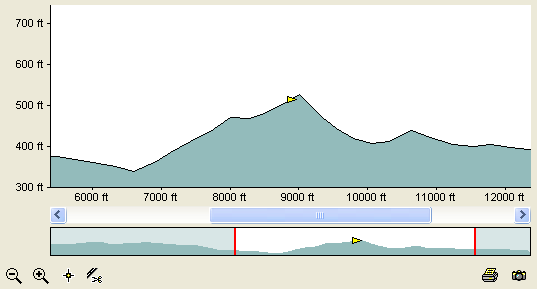
Zooming and Panning
The long thin profile at the bottom shows a profile of
the entire track. You can zoom in on a portion of the track by clicking the ![]() in the lower left corner. The red
lines on the lower profile show the portion of the track that is displayed in the main profile window.
in the lower left corner. The red
lines on the lower profile show the portion of the track that is displayed in the main profile window.
Use the scroll bar above the lower profile to pan along the zoomed profile.
Track Marker
The orange triangle near the top of the hill is the Track Marker. Click on the elevation profile to move the marker. As you move the marker, its location will be updated on any maps you currently have open, allowing you to accurately determine the locations of peaks and valleys on the map.
To create a new waypoint at the marker location, click the ![]() New Waypoint button.
New Waypoint button.
To split the track into two parts at the marker location, click the ![]() Split button.
Split button.
Track Selection
You can highlight a section of the elevation profile by dragging the mouse over the graph. This creates a Track Selection. As you draw the selection, it will appear on any maps you currently have open.
To delete the points in the Track Selection, click on the .
Other Commands
Right-click on the large profile window to display the shortcut menu, which contains commands to modify the track.
Buttons
 Zoom In button
- Zoom in to see part of the elevation profile in greater detail.
 Zoom Out button
- Zoom out to show more of the elevation profile.
 New Waypoint button
- Create a new waypoint at the marker location.
 Split button
- Split the track into two parts at the marker location.
 Print Preview button
- Show a preview of the printed elevation profile.
 Export Image button
- Export an image of the elevation profile.
Related Topics
© 1998-2024 TopoGrafix – 24 Kirkland Dr, Stow, MA – Email: support@expertgps.com